The 50 Mile race starts at 7:00AM FRIDAY at the same time as the 100 milers on the Bonneville Speedway and runs out to join the roads and trails that traverse the "islands"... mountains that seem to float on the Salt Flats.
There is a 14 hour cutoff for an official finish, and all finishers making the cutoff receive a finisher’s medallion. Signup Now!
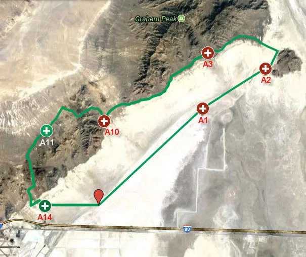
As a general description; you'll be running on the salt and compacted salt-sands for roughly 17 miles, then transition to dirt jeep road (double-track) for about 5 miles where you'll hit (Cobb Peak road). Then you'll split off from the 100 mile course for 9 miles of dirt road, followed by a technical double-track climb and descent of about 6 miles, a couple more miles of dirt road, then another double track climb of a mile or so with moderately technical descent of another mile or so back to the salt for the remainder of the course. I personally love the two climbs/descents on the 50 mile course... they are an exceptionally beautiful example of the desert mountains and offer a good technical respite ;) The course starts and finishes at the same location, so runners won't have to worry about shuttling vehicles or themselves.
Course Elevation

Course Marking
The course marking is very straight-forward and easy to follow. From the Start to Aid 2 we use re-bar with orange flagging. Through this section, the course is marked every 1/3-1/4 mile. After leaving Aid 2, the marking is every 0.3 mile with GREEN pin-flags, and flour arrows at each intersection. Intersections are also marked with pin-flags showing the correct direction, and three red pin-flags showing the wrong direction.
Course Directions
The course begins at the end of the Bonneville Speedway access road on the staging area for the Speedway. Once the gun goes off, head north following the flagging along the Speedway for 10 miles, passing Honey-Bucket portable toilets around mile 3-5 to Aid Station 1 at 10 miles.
You’ll be running on nearly 6 feet of solid salt for this entire section!
The surface is generally quite hard, similar to hard-pack dirt. However, if there’s been any moisture, it can be very sticky and you can accumulate some salt cakes on the bottom of your shoes… just keep running and it’ll fall off eventually.
From Aid 1 (Salt Flats), head north following the same flagging for almost three more miles, and then turn east following the same flagging and then pin-flags for about another 3 miles where you’ll reach Aid Station 2 (Now NO Post), at 15.5 miles. You’ll have transitioned off the salt and will now be on the classic firm sand of the salt basin. It’s a little like running on the beach near the water line. The big post stuck in the salt here is a mysterious relic from the past and serves as a great marker for the aid station.
From Lone Post, follow pin-flags north for just over a mile where you’ll intersect the hard-pack, dirt road that connects Floating Island to Silver Island, turn left following the big flour arrows and pin-flags and head west on that road. Follow this road due west for a mile and a half, where it enters the brushy landscape at the foot of Silver Island. The road ultimately winds around to head south, where it joins the Silver Island Loop road. Follow the flour arrows and pin-flagging south, then continue following the pin-flags to Aid Station 3 (Cobb Peak Road), at 22.6 miles
From Cobb Peak Road, continue south on East Silver Island Road for 9.9 miles to Aid Station 10 (Jeep Trail) at mile 32.5.
Leave Jeep Trail Aid Station on a narrow, rocky 4x4 road heading North-West. Follow this road as it turns west for 5 miles to where it joins West Sliver Island Loop Road again, and then head south for 2 miles to Aid Station 11 (Rock Pile) at 39.3 miles.
After leaving Rock Pile, follow West Silver Island Loop Road south for about 1.3 miles to a dirt road on the left, and following the signage and blue pin flags, make the mile climb up to a narrow pass, then enjoy running the fun ATV trail down to Ranch Road, cross it to the dirt road on the other side, and follow the blue flagging as you cross the saline canal, keep heading east to the intersection with Speedway Road. Turn left on Speedway Road and follow it north for just over a mile where you reach Aid Station 14 at mile 47.3 (Home Stretch).
After leaving AS 14 bear right onto the salt flats on the right side of the Speedway Access Road and head east staying about 50 yards from the Speedway Access road, ticking off the mile markers for your four mile sprint to the finish!